APACHE TRAIL ARIZONA
Wednesday February 21st 2007
 |
 |
|---|---|
Superstition Mountain just a little east of Apache Junction which is close to Mesa which, in turn, is a suburb of Phoenix. Did you follow all that? |
We will see a lot of rock formations like this today. Being from BC, it is a little hard to qualify this as a mountain???? |
 |
 |
A re-built Ghost Town Just off the road so it can be a quick stop. The road here is still paved |
It actually is a neat little spot worthwhile of a poke around |
 |
 |
We did not bother with the mine tour ... me in small places just doesn't work! |
There were three of these signs prominently displayed so everyone had to pass by at least one of them. The cynic in me asks "what happened to make this sign a necessity?" |
 |
 |
Of course, the obligatory cowboys just happened to ride by ... authentic ghost town .... |
Several miles further along the road is Tortilla Flat (nothing to do with Steinbeck ... his was in California. This place is known for its hamburgers and fries. We will have to take their word for it. |
 |
 |
The Salt River was dammed by the Roosevelt Dam which formed three lakes: The Saguaro, The Canyon and The Apache. This one is Canyon Lake |
And they weren't kidding ... |
 |
 |
The Apache at the east end. The blue water and the stark rock of the desert sure makes a startling contrast |
This is the only spot on the road that follows a tributary river ... hence the trees in the middle of the desert. |
 |
 |
I have included quite a few pictures of the road and the surrounding cliffs. There were quite a few cars on the road the day we went in, but not too many to make it uncomfortable |
One lane going down and the previous picture was one lane going up. By the way ... no big trucks allowed!!! |
 |
 |
I love that sign ... ignore that and it was about 100 feet straight down -- through the cactus -- to the lake |
Sure desolate country ... the road is gravel with pot holes but in general, it is pretty well maintained. Why you ask? It actually is a State Highway!!! |
 |
 |
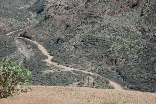
We got a little brave and stopped and looked down ... notice the car??? |
The slight red box? in the middle of it is what is left of a couple of cars that didn't make the turn!!! They are about 250 feet off the road. |
 |
 |
10 MPH is a joke in many spots!! |
Just beyond this cactus is a 200 foot drop |
 |
 |
Another turn warning >>>>> |
Elsie took this through the windshield. Anything coming at you??? who knows!!! |
 |
 |
Looking down (we did a lot of that) at one of the little one-lane bridges |
After one more switchback and a picture of the same bridge |
 |
 |
There were a lot of these bridges ... i sure would not want to take Harvey through here at any speed |
High enough for Harvey, but .... |
 |
 |
If you were a geologist the erosion here is sure breathtaking |
It just did not end... |
 |
 |
The colours are breathtaking and change as the sun moves thorough the day |
You sure get to appreciate the Saguaro Cactus. This one would be well over 100 years old. |
|
 |
It would be over 25 feet tall |
A whole forest of them |
 |
 |
As you can see ... this place sure has a lot of activities. When it is over 115F in Phoenix, this would be a great place to come for the weekend. |
In the summer the lake if full of boats and swimmers |
 |
 |
The saguaro cactus stands guard on Apache Lake |
Still 12 miles to go ... and the road changes very little... |
 |
 |
Finally the end of the gravel road and Roosevelt Dam-- the end of a truly remarkable drive. This drive ranks up there with the "Going to the Sun" highway in Montana. A MUST DO if you ever get to this area! |
This is the Roosevelt Dam Bridge ... The road is now paved and we headed towards Globe and then back to Casa Grande. A good Day!!!!! |